.png)
Cartographic Propaganda in Geopolitics - Map Games
- THE GEOSTRATA
- Nov 18, 2021
- 6 min read
Updated: Oct 31, 2022
Nations love to project power and display greatness through propaganda and media. Likewise, nations convey various messages and display power through maps. Maps are a great illustrative way of conveying or projecting power messages to allies and enemies. Maps show areas of influence of a nation-state.
They can be deceptive as well as informative. But in the arena of geopolitics, they can be used as power projection tools. Since the old ages of European colonial and sea power expansion, maps have been used to show areas of influence and control between Spanish and the Portuguese. In the Cold war era, the same cartographic tools were used to show influence and power in one's bloc.
Apart from geopolitical gains, maps have been used to project civilisational superiority like Greenland is shown larger than Africa on the mercator map projection. The imperial federation map which was produced in 1886 had a sole purpose of showing britishers as the world rulers and the most land controlling entity on the face of the earth.

This map had only one purpose - propaganda projection. It had no navigational purpose. Also the map showing Russia’s Czar on an octopus with its tentacles trying to grab the rest of Europe. In this piece we will go through the map-making power struggles of Nations and how they use maps as a mode of both national political strategy, power projection and as a tool of propaganda.

MAPS AS A TOOL OF PROPAGANDA
Nations use maps to exert pressure on enemies and affirm allies of their bloc influence. The purpose of projecting power through maps is to limit the adversary's influence through print or media. When a map is made popular enough, it can limit the enemy’s ways of countering the public psyche that is drawn against them. Many times, nations show through maps, alliance and friendship. This was a common practice during the Cold War era. The Soviet bloc or the eastern bloc, which was geographically closer to communist nations like the People's Republic of China and also bigger in size,used this very geographical location and size to its structural advantage.
Soviet cartographers used to show a big communist symbol on the world map in communist red and gold on the eastern bloc states. The use of eye-catching colors and fonts was deliberate in an attempt to show to the other side the grandeur and power of the other bloc. Soviets also used this projection of power as a way of portraying solidarity and friendship through maps among the fellow eastern bloc states. Propaganda has also been targeted towards the normal public who doesn’t really have the level of knowledge. So, they can’t really recognise what is deceptive and what is the truth when it comes to the map world. Likewise, the western powers have used their set of propaganda machines to demonise and delegitimize enemy powers like the Nazis, Soviets and the Cubans.

During the Second World War, The Western powers used to publish maps which were deceptive and delegitimizing, showing Nazism’s swastika as a shadow of darkness over the Turkish lands which was evil and sitting on the European lands or the German spider with Hitler’s head trying to take over the whole Europe and Africa. On the other side, Britishers were shown as a big spider, trying to steal the entire European continent. In one map, Churchill was shown as a big-head western colonialist who wanted to grab Africa and other parts of the World.
Cartography is a powerful tool to influence people’s beliefs and mindset about a topic or an issue. Map makers have the power to show their nations as big as they want, alter the national boundaries and change the power dynamics in the minds of the ordinally public. This is also used as a political message to the nation whose land is included in the map published by the adversary.
The aim of the nation-state is simple yet powerful to show the other side that they are not recognising a particular land area as part of someone else. This plays with the status quo. In recent years, our subcontinent has seen disputes being raised up by propaganda of cartographic projections. Maps published by Pakistan and Nepal which include India’s land,shows the changing dynamics and geopolitical interests of the nations concerned. Maps can convey a lot through the slightest of change. Nepal’s assertion of having control over India’s Kalapani area shows the deepening divide between the two neighbours. All conveyed by just a change of map on official level and coat of arms.
MAPS AS TOOLS OF EMOTION AND NATIONAL PRIDE
Maps and flags are two of the most easily recognized symbols of a nation-state. They are not mere geographical or geometrical shapes. They are living souls in themselves. Looking at one’s national flag and map invokes pride, patriotism and a sense of belonging along with responsibility. There is a reason why adversaries use cartographic propaganda because it disrupts, downgrades and attacks the very same sense of pride and belonging. Maps are psychologically embedded in our memories. I can be almost cent percent sure that when I speak of India or mention the name of our nation to you as a reader you will have an image of India’s map and the grand tiranga in your mind and this is because you and your soul somewhere deep in there knows where it belongs to. This sense of belongingness is powerful and can be used as a potent weapon of sedition if played or destroyed.
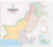
Pakistani cartographers and officials try to disrupt this very psyche and belongingness of ours when they portray Jammu and Kashmir not as a part of India. To us the map looks empty or unfamiliar when we see it through that angle. This unfamiliarity is a powerful propaganda tool of nation-states. When the Americans were on the edge of the Sunrise - Japanese empire,their propaganda was to show Japan shrinking by the might of American forces and aircrafts. This is a powerful projection to win support at home and destroy hopes behind the enemy lines. Imagine the state of an ordinary Japanese person looking at a poster which shows the Japanese empire shrinking in the middle of a world war. Maps break or make solidarity in between and outside.

During the First World War, the Germans published a map showing them as surrounded by evil British, French, and other European forces. The propaganda here was of winning support at home against evil and to encourage participation in the war effort and to portray the Britishers and French as enemies who were trying to take all of Germany. Maps like these are not only propaganda tools but also national political strategy tools. Likewise, the Research Institute of America in 1956 published a map showing Soviet influence taking over the world. Aim of this map was to bring up anti-communist support in the nation and within the allies. Chinese officials recently published a map showing in vertical context, the South China Sea region as entirely of China.
This projection invokes a national sense of belonging and owning to the region. Chinese now have control over the South China Sea in their psyche. This shows how maps can be used to create and destroy national interests and mindsets among the masses. Making maps a powerful political tool.
MAPS ARE EVOLVING
Map based cartographics propaganda is also evolving along with the maps. Nations nowadays have greater means of propagating through the platforms of social media, print media and television. The Internet has fast paced the speed of propaganda. Which makes it more lethal and disruptive. Nations use platforms like twitter to rapidly post through tens of millions of accounts, maps that they believe are the ones which should be accepted and obeyed. Be it, Chinese accounts posting showing South China Sea and Taiwan as part of the People’s republic or Pakistanis showing Kashmir as part of Pakistan. Many official platforms like the United Nations, World Trade Organisation and others are used to display maps through posters or official websites to project and state a clear political message.
The future map propaganda wars have shifted to Google and Snapchat where in Pakistan, Kashmir is shown as part of Pakistan only and in India, it is shown as part of India. Mass boycotts and protests are held if map projection goes wrong according to masses of a nation. Recently, television media giant, BBC issued an apology for showing Jammu and Kashmir as not a part of India.
These evolving map propaganda platforms and disruptive media platforms show us that maps and their national political strategy, propaganda use and disruptive importance is here to stay. Maps are embedded in our memory which makes control of propaganda of maps more important than ever in the 21st century.
——————————-—
BY HARSH SURI
CO-FOUNDER THE GEOSTRATA
thegeostrata@gmail.com